BIM and GIS make Cities Smarter : Infraworks-Civil 3d-ArcGIS

Why take this course?
🌆 Course Title: BIM and GIS Make Cities Smarter: Infraworks-Civil 3D-ArcGIS 🚀
Headline: The Great Collaboration Between BIM and GIS for Smart City Information Management - Learn the New Process for a New Chance! 🌇✨
Course Description:
Are you ready to embark on a transformative journey in your professional career? Ayman Kandeel, CEng ®, PMP ®, MICE®, ACP®, RICS-BIM®, an esteemed course instructor, invites you to explore the synergy between Building Information Modeling (BIM) and Geographic Information Systems (GIS) in the context of smart city development. This comprehensive online course, "BIM and GIS Make Cities Smarter: Infraworks-Civil 3D-ArcGIS," is designed to revolutionize your approach to infrastructure projects and asset management within urban environments.
🔍 Why This Course?
In an era where urbanization is rapidly shaping our world, the integration of BIM and GIS technologies is paramount for creating smarter, more efficient cities. This course will equip you with the skills to leverage these powerful tools in a way that transcends traditional engineering roles—positioning you as a city engineer at the forefront of innovation and sustainability.
📚 Course Highlights:
-
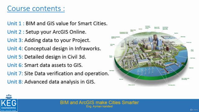
Unit 1: BIM and GIS Value for Smart Cities - Discover how these technologies can enhance decision-making processes and contribute to the sustainable development of urban areas.
-
Unit 2: Setup your ArcGIS Online - Learn to navigate and configure the essential GIS platform for your smart city projects.
-
Unit 3: Adding Data to Your Project - Master the techniques for integrating BIM data seamlessly into your GIS environment.
-
Unit 4: Conceptual Design in Infraworks - Explore conceptual design with a focus on urban development and infrastructure planning.
-
Unit 5: Detailed Design in Civil 3D - Delve into the detailed design phase, where precision meets functionality.
-
Unit 6: Smart Data Assets to GIS - Understand how to transition BIM data into smart, actionable GIS assets.
-
Unit 7: Site Data Verification and Operation - Ensure accuracy and reliability of your project data during both design and operational phases.
-
Unit 8: Advanced Data Analysis in GIS - Harness the power of GIS for sophisticated analysis, enabling you to make informed, data-driven decisions.
🎓 Course Benefits:
- Gain a deep understanding of how BIM and GIS complement each other in infrastructure projects.
- Learn best practices for managing complex urban environments.
- Enhance your asset management skills by utilizing smart data assets.
- Improve your ability to maintain and operate infrastructure with precision.
- Access advanced data analysis techniques to support decision-making processes.
🤝 For Whom?
This course is perfect for civil engineers, BIM engineers, urban planners, and any professionals involved in the lifecycle of infrastructure projects who aim to leverage cutting-edge technologies for smart city development.
Take the new chance to expand your expertise and become a pivotal player in the smart city revolution. Enroll in "BIM and GIS Make Cities Smarter: Infraworks-Civil 3D-ArcGIS" today and join a community of professionals dedicated to shaping the future of urban environments! 🌟
Sign up now and be part of the smart city evolution with Ayman Kandeel, your guide to mastering BIM and GIS integration. Let's build smarter, not harder, together! 🚀🏭🌆
Course Gallery


Loading charts...